The Belgian Part of the North Sea is home to a variety of seaweed species and is considered as a suitable environment for seaweed aquaculture. LifeWatch offers a range of data products which can benefit macroalgae aquaculture stakeholders.
A list of extant marine macroalgae species in the BPNS can be accessed below:
- Green algae Chlorophyta
- Red algae Rhodophyta
- Brown algae Phaeophyceae
Below, some macroalgae species of commercial interest are listed and discussed in detail. Factsheets are provided for each species together with species distribution modelling (SDM) maps. Links to relevant dataproducts in order to create SDM maps can also be found on this page.

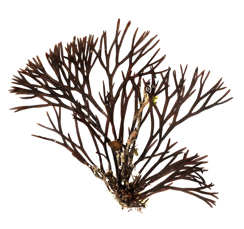
Rockweed (Dutch: knotswier) - Ascophyllum nodosum (Linnaeus) Le Jolis, 1863
Ascophyllum nodosum is a large, common cold-water seaweed or brown alga (Phaeophyceae) from the family Fucaceae, being the only species of the genus Ascophyllum. It is a seaweed that only grows in the northern Atlantic Ocean, also known in localities as feamainn bhuí, rockweed, Norwegian kelp, knotted kelp, knotted wrack or egg wrack. It is common on the north-western coast of Europe (from Svalbard to Portugal) including east Greenland and the north-eastern coast of North America, its range further south is being limited by warmer ocean waters.
Fact Sheet WoRMS OBIS distribution map
© dozen
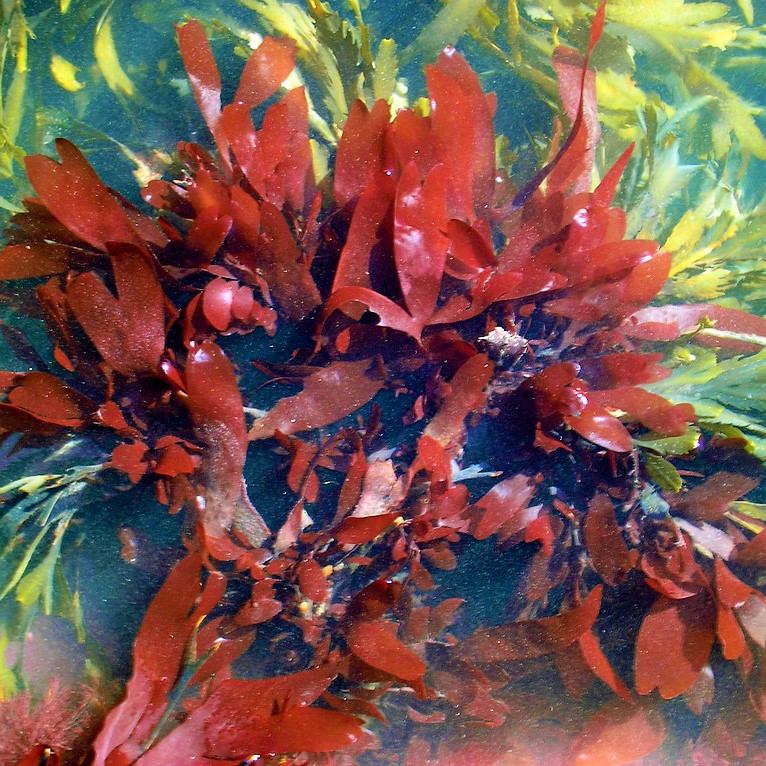
Red Seaweed - Furcellaria lumbricalis (Hudson) J.V.Lamouroux, 1813
Furcellaria lumbricalis is a red macroalgae (Rhodophyta) belonging to the Furcellariaceae family. The species can grow up to 30 cm in length and can be found on rocky substrates in shallow subtidal zones along the North East Atlantic Coast from Spitsbergen to Spain. Outside Europe, F. lumbricalis can be found along the East Coast of North America, in Pakistan and India. It is mainly found in sheltered areas and can tolerate low salinity levels. This species is of commercial interest because of its remarkable polysaccharide that can be found in the cell wall, furcellaran. Furcellaran is used as a gelling agent in food- and pharmaceutical industries.
Fact Sheet WoRMS OBIS Distribution Map
©Paul Sterry/Nature Photographers
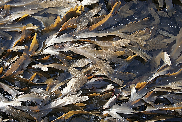
Toothed wrack (Dutch: gezaagde zee-eik) - Fucus serratus Linnaeus, 1753
Fucus serratus or the toothed wrack is a large brown algae (Phaeophycea) widely distributed in North Atlantic coastal areas in Europe and the U.S.. The toothed wrack is very similar to other species of its genus such as Fucus vesiculosus and Fucus spiralis. Individuals form dense beds along rocky shores in the intertidal zone. Preferably in sheltered areas. F. serratus is cultivated for cosmetics and liquid fertilizer.
Fact Sheet WoRMS OBIS Distribution Map
©Anne Burgess
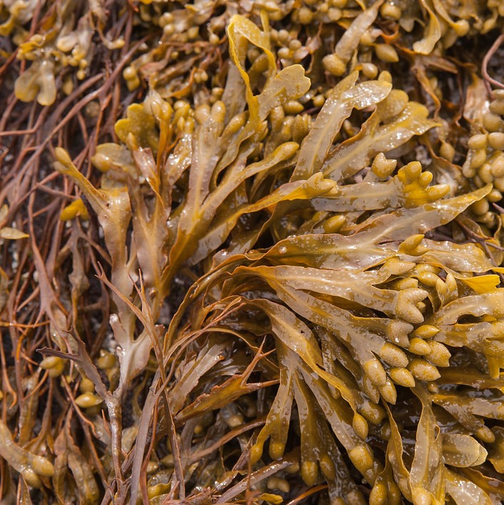
Bladder wrack (Dutch: gewone zee-eik of blaaswier ) - Fucus vesiculosus Linnaeus, 1753
Fucus vesiculosus, also known as bladder wrack, is a perennial large brown algae (Phaeophycea) belonging to the Fucaceae family, just as the toothed wrack. It can be found along the North East Atlantic coasts from Spitsbergen to Portugal and along the eastern shores of North America. The species is also a resident in the Faroes and the Baltic Sea. The bladder wrack occupies the intertidal zone just above the Fucus serratus zone and co-occurs with rockweed (Ascophyllum nodosum). The species can be recognized by its distinctive air bladders which makes its fronds float. Fucus vesiculosus is of commercial interest for its chemical constituents such as mucilage, algin, iodin etc.
Fact Sheet WoRMS OBIS Distribution Map
©Arild.Espelien
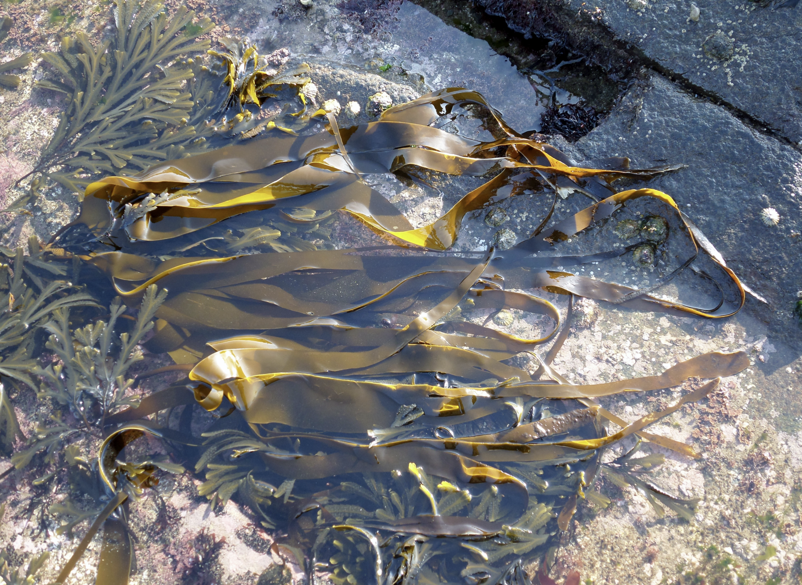
Oarweed (Dutch: vingerwier) - Laminaria digitata (Hudson) J.V.Lamouroux, 1813
Laminaria digitata, also known as Oarweed is a large kelp species (Laminariales) along the Atlantic coasts of Europe ranging from Northern Russia to the Canary Islands. It's also present in the Baltic and Black Sea. Hard substrates in the lower intertidal and subtidal zones (up to 20 m depth) are the preferred habitat of L. digitata. The kelp species favors moderately to very exposed areas with strong wave currents. Because of the high concentrations of algin in the cell walls, the algae is mainly grown for the production of alginic acid which is used in pharmaceutical products, cosmetics, food industry...
Fact Sheet WoRMS OBIS Distribution Map
© Bjoertvedt

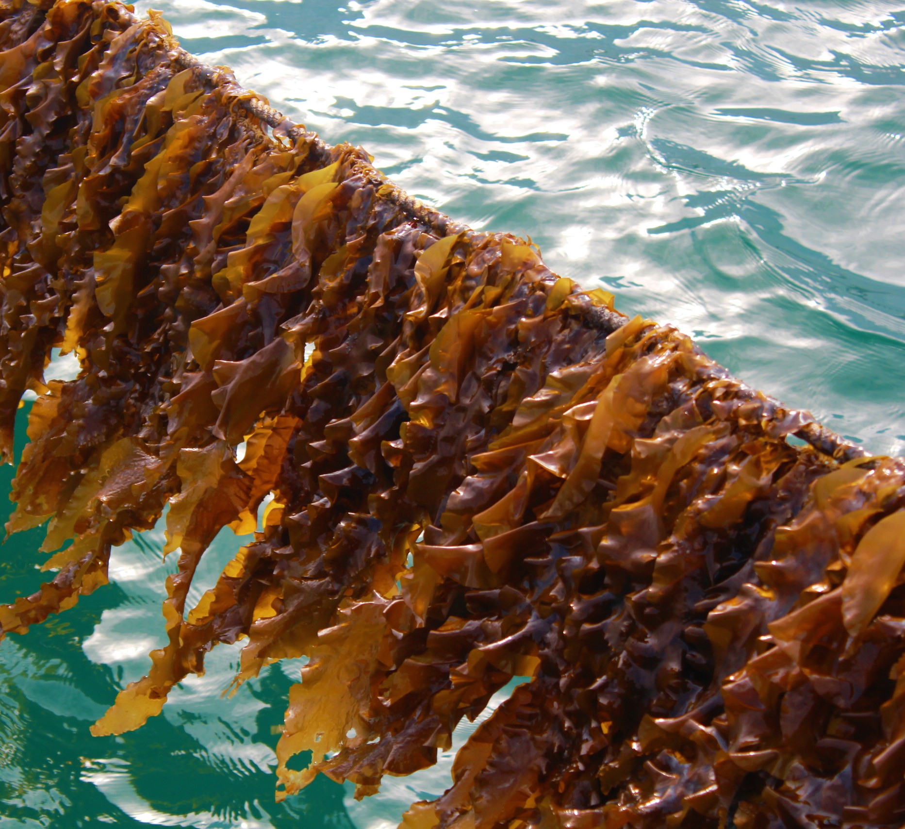
Tangle - Laminaria hyperborea (Gunnerus) Foslie, 1884
Laminaria hyperborea or commonly known as tangle or cuvie is another large kelp species (Laminarialis) that may grow up to 3.5 meters under the right environmental conditions. Tangle can only be found in the North East Atlantic from the northern coast of Iceland to mid-Portugal but is absent in the Bay of Biscay. High density beds of up to 36 meters are formed in exposed areas in the subtidal zone. This large kelp species is of high interest to the industry because of its high carbohydrate content which makes Laminaria hyperborea a possible candidate to create large volumes of biofuel.
Fact Sheet WoRMS OBIS Distribution Map
©Per Arvid Åsen
Dulse (Dutch: rood lapwier) - Palmaria palmata (Linnaeus) F. Weber & D. Mohr, 1805
Dulse or Palmaria palmata is a small cold-water foliose, red algae (Rhodophyta) that generally grows up to 20 - 50 cm. This red algae's distribution ranges from Northern Russia to Portugal in the North East Atlantic and from Canada to New Jersey in the North West Atlantic. It may also be found in Japan and Korea. Dulse is characterized by its often epiphytic lifestyle, growing on the stipes of Laminaria hyperborea. Palmaria palmata is also seen growing independently on hard substrates. Intertidal and subtidal zones up to a depth of 20 meters are preferred by P. palmata. Dulse is cultured for various culinary uses.
©Gwylan
Sugar Kelp (Dutch: suikerwier ) - Saccharina latissima (Linnaeus) C.E. Lane, C. Mayes, Druehl & G.W. Saunders, 2006
Saccharina latissima is a brown algae (Phaeophyceae) of the family Laminariaceae, commonly called sugar kelp, sea belt, or Devil's apron. It is found in North Atlantic waters from Northern Russia to mid-Portugal, around Iceland, Greenland and along the eastern coast of the U.S.. The pacific coasts of the U.S., Japan and the Bering Straits are also populated with sugar kelp. S. latissima thrives in the subtidal zone up to a depth of 30 meters. S. latissima is cultured for various industries ranging such as cosmetics, the food industry or the production of biofuels and biofilters.
Fact Sheet WoRMS OBIS Distribution Map
©Queen's University Belfast KarenMooney
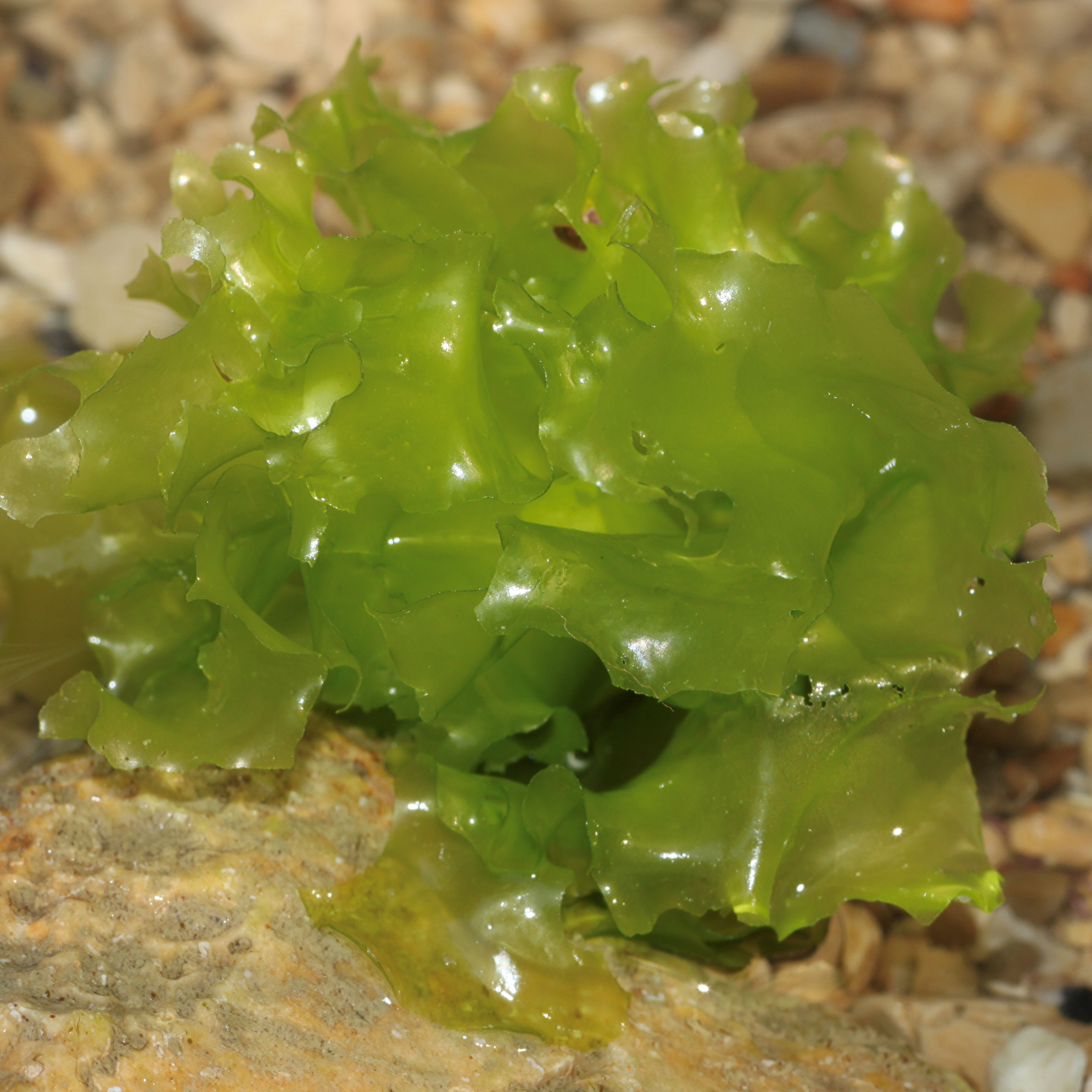
Sea lettuce (Dutch: Zee sla) - Ulva lactuca Linnaeus, 1753
Ulva lactuca is a green seaweed (Chlorophyta) found in Northeast Atlantic and North Pacific, commonly known as sea lettuce. It's present all around the British Isles, the coast of France and along the coastal areas of the North Sea up to Denmark. It prefers rocky shores and a moderate to low wave exposure and may also be found in shallow waters near the low watermark. Sea lettuce thrives in brackish water, estuaries and thrives in eutrophic conditions. Ulva lactuca is cultured as a food product or for the pharmaceutical industry.
©Holger Krisp
To get an idea of the geographical distribution of your seaweed species of interest, the OBIS Mapper can be consulted. The mapper allows the user to inspect and visualize OBIS datasets while applying various filters (taxonomic, geographic, time...). Natural occurrences of seaweed species can be downloaded and visualized using the OBIS data explore portal.
The geographical distribution of macroalgae depends on many different environmental variables. Due to climate change, temperature will become an important variable influencing species' distribution. In order to predict if a certain species or group of species will thrive in a certain location, now or in the future, SDM (species distribution modelling) maps can be a useful tool
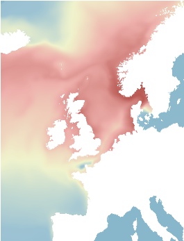
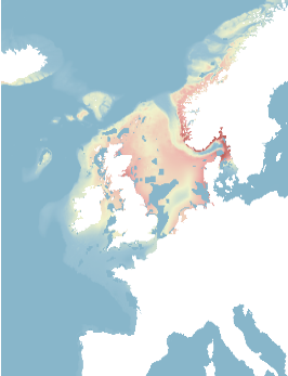
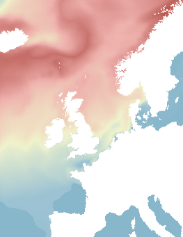
Habitat suitability maps for Laminaria digitata where the optimal habitat is colored red and poor habitats are colored blue. From left to right: a map created with environmental variables (temperature, salinity, heat, turbidity, irradiance, nitrate). Secondly, you have a map created with the previously mentioned environmental variables, depth and where marine spatial planning is included. The last map takes the impact of climate change into consideration when modeling the species distribution in the future (2100, RCP: 8.5) (Westmeijer et al., 2019)
A couple of useful LifeWatch tools that are available to create such maps:
The sdmpredictors R package for species distribution modelling.
The LifeWatch BIO - ORACLE package of gridded marine data layers for ecological modelling