Sea state and wind can strongly impact maritime industry activities. Regarding marine safety, transport possibility and damage to structures, the availability of in situ wind and sea state observations is still very limited. EMODnet Physics and Meetnet Vlaamse Banken are providing the data to better analyze historical and live records of wind and sea state from the Belgian Part of the North Sea (BPNS).
Here you will find concrete and easy instructions to access useful BPNS sea state and wind-related data from these reliable and up-to-date sources.
Wind

stations with wind data in the BPNS
Wind monitoring with EMODnet
There are four stations recording wind data in the BPNS: Westhinder, Nieuwpoort Buoy, Wandelaar and Scheur Wielingen. In order to access wind information from these stations select the filter 'parameters -> Wind' within the EMODnet interface. Station specific data can be retrieved by clicking any station on the map or drawing a polygon surrounding multiple stations.
The following links give direct access to EMODnet wind direction and frequency data at the four BPNS wind measuring stations. Additionally, EMODnet provides average and maximum wind speed per hour as products.
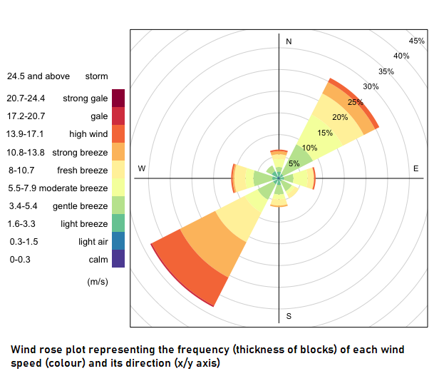
Hereunder is a wind rose plot with data from EMODnet at Westhinder station from March to August 2020. These plots can be made with the R package "openair". You can make your own wind rose plot with EMODnet data in R using the script in the link.
Live wind direction and speed data from EMODnet Physics can be accessed any time. Click on the webviewer to see more.

Global wind in-situ data at sea level/ground from EMODnet
Sea State
filter and stations with sea state data in the BPNS
Sea State monitoring with EMODnet
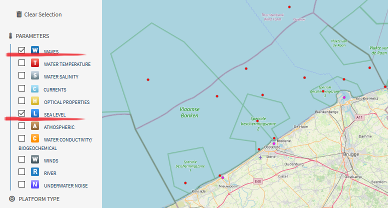
EMODnet counts with a large number of stations within the BPNS making continuous recordings of sea state parameters, mainly wave height statistics. Sea level is an additional sea state variable measured at these stations. Data of these parameters can be accessed selecting the filter parameters -> Waves and Sea level within the EMODnet interface. Station specific data can be retrieved by clicking any station on the map or drawing a polygon surrounding multiple stations.
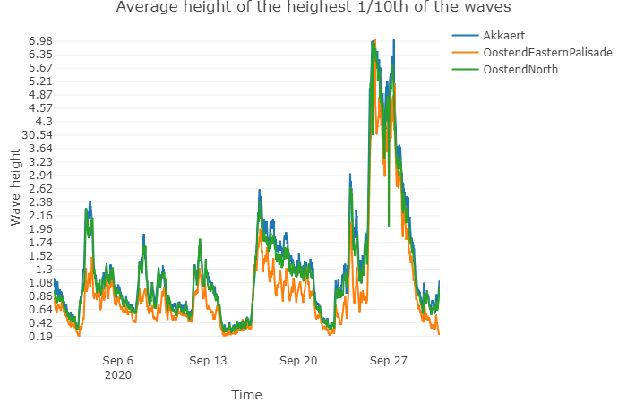
Wave height is periodically recorded by several stations in the BPNS and values are stored in the publicly available EMODnet database. Wave heights are subsetted in different measurement units and parameters, namely: significant wave height, height of highest 1/10 waves and zero crossing wave period. Additionally, maximum, minimum and average values are given for each parameter and displayed in interactive plots. Wave data is linked below for four stations.
You can make your own plots comparing wave height parameters at different stations. Wave height data can be downloaded from the links above or directly from the EMODnet interface. All information on how to download the data and make the plots in R can be found in the script below.
Alternative Data Sources
Meetnet Vlaamse Banken is a platform from the Flemish Government that includes data from wind and sea state from multiple stations in the BPNS, mostly overlapping with EMODnet's sources. Data can be downloaded and reproduced for personal use if provided the source. More information on intellectual properties can be found in the disclaimer section of the Meetnet Vlaamse Banken website.
The Agency for Maritime Services and Coast Department Coast (MDK) falls under the Flemish Ministry of Mobility and Public Works and is source of some of the wind and sea state data displayed in Meetnet Vlaamse Banen and EMODnet. Its data can be accessed through the Flemish hydrography section in their webpage.
All data used in this page was made available by the EMODnet Physics project, www.emodnet-physics.eu/map, funded by the European Commission Directorate General for Maritime Affairs and Fisheries.
Data were made available by EMODnet Physics, in collaboration with Copernicus Marine Service (CMEMS) and EuroGOOS ROOSs INSTAC where data originator and data center is: Agency for Maritime Services and Coast Department Coast (MDK) for wind data and Sea State data at Nieuwpoort buoy, Westhinder, Wandelaar and Scheur Wielingen maritime stations.